
Hyperspectral Imaging for Environmental Research
Balloon experiment • Designed 2024 • Launched 2024
Mission Completed
100%
HEIMDAL is a student-led space project from Aarhus University and the University of Southern Denmark, developed as part of the REXUS/BEXUS programme. It demonstrates the use of hyperspectral imaging to classify land cover and biodiversity, serving as a precursor to the upcoming DISCO-3 satellite mission.
The primary objective of HEIMDAL is to validate a hyperspectral imaging system for Earth observation from near-space altitudes (roughly 20–35 km). With this mission, students aim to test instrument stability, image quality, and environmental resilience of hardware designed to eventually be used on space missions. In addition, the project serves as an educational platform, giving participants real experience with balloon launch operations, data acquisition, and remote sensing workflows.
Balloon Experiment
Payload:
The payload consists of a hyperspectral camera system designed to capture spectral data for land classification, biomass detection, and cloud-snow discrimination. Supporting components include power supply, thermal management, and structural mounting solutions.
Communications:
Communication is limited to basic telemetry and downlink during flight. Scientific data are primarily stored onboard and retrieved post-landing. Efficient data handling and redundancy are ensured through onboard software and backup system
The HEIMDAL experiment was launched in October 2024 from Esrange Space Center in Kiruna, Sweden, as part of the 15th BEXUS cycle (Balloon EXperiments for University Students).
The H.E.I.M.D.A.L experiment is launched aboard BEXUS 35, as part of the REXUS/BEXUS programme – a bilateral student programme jointly run by the German Aerospace Center (DLR) and the Swedish National Space Agency (SNSA). The programme enables university students to design and fly experiments on high-altitude balloons (BEXUS) or sounding rockets (REXUS).
Throughout the project, the HEIMDAL team has received invaluable technical support and guidance from experts at DLR, SSC (Swedish Space Corporation), ZARM, and ESA. This collaboration has been fundamental to the project’s development and successful integration into the BEXUS mission.
A major contributor to the project is the company NewTec, based in Odense, which has provided the team with the hyperspectral camera, the core instrument of the experiment, along with extensive technical guidance throughout the design and development process.


What is Hyperspectral Imaging?
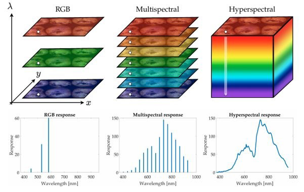
Hyperspectral imaging (HSI) is an advanced imaging technique where each pixel in an image contains a full light spectrum, far beyond the typical red, green, and blue channels. This allows each pixel to carry a unique spectral signature that can be used to identify materials and biological content – such as vegetation types, soil composition, or snow.
HEIMDAL demonstrates how this technology can be applied to:
- Classify land cover (e.g., forests, farmland, urban areas).
- Differentiate clouds from snow in the atmosphere.
Identify biomass and wetlands using spectral data.
By comparing recorded spectral data to known reference spectra, HEIMDAL aims to accurately detect and categorize what’s on the Earth’s surface – all from the stratosphere.
Land cover classification
Land cover classification relies on hyperspectral data’s ability to capture distinct spectral fingerprints of different materials. The data is divided into numerous spectral bands and statistical or machine learning algorithms are employed to identify patterns and associate them with specific land cover classes. For example, healthy vegetation shows strong absorption features in the visible and near-infrared regions, while water bodies have unique spectral responses. This detailed land cover classification is pivotal for land-use planning, environmental monitoring, and disaster management.
Cloud-snow discrimination
Hyperspectral imaging is capable of distinguishing between clouds and snow by examining spectral signatures. Clouds typically exhibit higher reflectance in visible and near- infrared wavelengths due to sunlight scattering by water droplets. Conversely, snow crystals display distinctive absorption features in the mid-infrared spectrum. This capability is instrumental in meteorology, aiding accurate weather forecasting and climate research.
Biomass classification
Hyperspectral imaging contributes significantly to biomass estimation and classification. Different plant species and vegetation types have unique spectral signatures, particularly in the visible and near-infrared ranges. Healthy vegetation have high reflectance in the near-infrared due to chlorophyll absorption, while stressed or unhealthy vegetation displays different spectral responses. By analyzing hyperspectral data and using machine learning techniques we can determine the composition and health of biomes.
Curious to know more?
What to discover


Can the climate crisis be photographed from space?
A group of Danish students are currently in northern Sweden, where they are investigating whether a Danish-developed camera can take high-quality images from the stratosphere.
Ratatosk